Location
Layout | Geography | Directions | Map
Layout
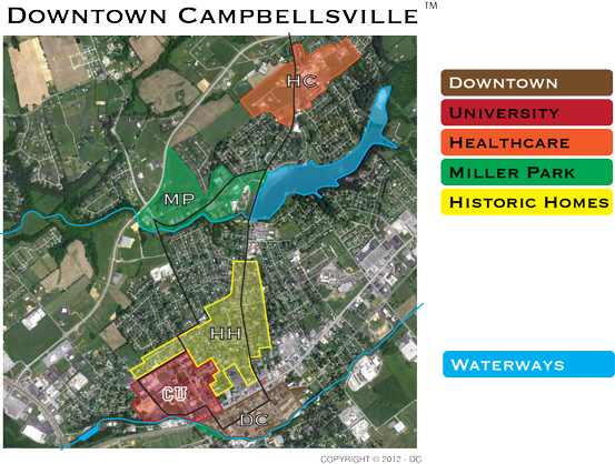
There are 6 notable areas of Downtown Campbellsville
- DC – Downtown Campbellsville Historic District
- CU – Campbellsville University
- HC – Health Care – Taylor Regional Hospital
- MP – Miller Park and waterway
- HH – Historic Homes
- WW – Waterways
Additionally, the region’s Green River Lake plays a vital role in local tourism and recreation (not shown above, instead shown below in the interactive map)
Geography
- Campbellsville is near geographic center of Kentucky at 37°20′45″N 85°20′44″W
- Campbellsville is the northern most part of the south.
- Campbellsville is in the Eastern Time Zone. Just 8 miles from the Central Time Zone.
- Campbellsville is mid-way between Chicago and Atlanta.
- Campbellsville is in the center of Louisville-Lexington-Nashville-Knoxville.
- Campbellsville is mid-way between I-65 and I-75. And just north of the future I-66 corridor.
- Campbellsville has 3 scenic routes of travel via the Lincoln Parkway, Bluegrass Parkway, Cumberland Parkway
Directions
Travel Routes – Campbellsville is in the center of these 4 cities. Each route is about 90 minutes and travels along a scenic parkway.
- LOUISVILLE KY – I-65 S Exit 91 Elizabethtown to Lincoln Parkway to Campbellsville
- LEXINGTON KY – Take Versailles Rd to Blue Grass Parkway to 555 to 55 Lebanon to Campbellsville
- LONDON KY – From I-75 N Exit 41 London KY to Somerset to Cumberland Parkway to Columbia to Campbellsville
- BOWLING GREEN KY – From I-65 S Exit 43 Cumberland Parkway to Columbia to Campbellsville
